World map
|
|
This article relies largely or entirely upon a single source. Please help improve this article by introducing citations to additional sources. (July 2011) |

A world map is a map of the surface of the Earth, which may be made using any of a number of different map projections. A map projection is any method of representing the surface of a sphere or other three-dimensional body on a plane.
Maps of the world are often either 'political' or 'physical'. The most important purpose of the political map is to show territorial borders; the purpose of the physical map is to show features of geography such as mountains, soil type or land use. Geological maps show not only the physical surface, but characteristics of the underlying rock, fault lines, and subsurface structures.
Contents |
[edit] Projections

Maps that depict the surface of the Earth use a projection, a way of translating the three-dimensional real surface of the geoid to a two-dimensional picture. Perhaps the best-known world-map projection is the Mercator Projection, originally designed as a form of nautical chart.
Aeroplane pilots use aeronautical charts based on a Lambert conformal conic projection, in which a cone is laid over the section of the earth to be mapped. The cone intersects the sphere (the earth) at one or two parallels which are chosen as standard lines. This allows the pilots to plot a great circle (shortest distance) route approximation on a flat, two-dimensional chart.


[edit] Thematic
-

Clickable world map (with climate classification)
-

Elevation map
-
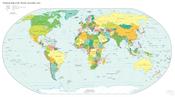
A simple political map of the World as of 2011
-

Pacific-centric map (more commonly used in East Asian countries and Australia)
-

Present day Earth altimetry and bathymetry (Mollweide projection)
-

Topographical map of the world
-

map of anthropogenic CO2 emission by country
-

UN Human Development Index by country as of 2008
-

Volcano Map
-

world map showing the continents as of 200 million years ago (Triassic period)


[edit] Historical
-

World map according to Posidonius (150-130 B.C.), drawn in 1628 A.D.
-

Tabula Rogeriana world map by Muhammad al-Idrisi in 1154. Note that north is to the bottom


[edit] See also
[edit] Projections
- Albers projection
- Azimuthal conformal projection: see Stereographic projection
- Azimuthal equidistant projection
- Behrmann projection
- Bonne projection
- Bottomley projection
- Cahill octahedral Butterfly projection: see Bernard J.S. Cahill
- Craig retroazimuthal projection
- Dymaxion projection
- Equirectangular projection
- Gall–Peters projection
- Gnomonic projection
- Goode homolosine projection
- Hammer projection
- Hobo–Dyer projection
- Lambert azimuthal equal-area projection
- Lambert conformal conic projection
- Lambert cylindrical equal-area projection
- Littrow projection
- Mercator projection
- Miller cylindrical projection
- Mollweide projection
- Peirce quincuncial projection
- Peters projection
- Plate carrée projection
- Polyconic projection
- Robinson projection
- Sinusoidal projection
- Stereographic projection
- Transverse Mercator projection
- Waterman butterfly projection
- Werner projection
- Winkel Tripel projection
[edit] References
- ^ Large-Scale Distortions in Map Projections, 2007, David M. Goldberg & J. Richard Gott III, 2007, V42 N4.
[edit] External links
| Wikimedia Commons has media related to: Maps of the world |
| Wikibooks has more on the topic of |
- World map at WikiMapia
- World maps from the CIA World Factbook
- An interactive JAVA applet to study deformations (area, distance, angle) of world maps
- World maps in PDF format
- United Nations Map Library
- University of Texas Map Collection
- Java world map allowing different projections and orientations
- (European Digital Archive on the Soil Maps of the World - EuDASM)
- Brief History of Maps and Cartography
- Brief History of Maps and Cartography
- GinkgoMaps - Free Digital World Maps published under the CC-by Licence
- American Geographical Society Library Digital Map Collection
- Fullscreen pan and zoom world map